Browse by Collection: UCSD Research Data Collections
View current collections below. Click an image or link for a full description.
Page 3 of 11
Search Results
-
 Collection
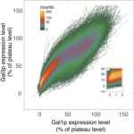
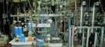
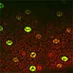
Data from: A Living Vector Field Reveals Constraints on Galactose Network Induction in Yeast
- To study how cellular traits produce population phenotypes, we built living vector fields from single-cell timecourses of the proteins Gal3p and Gal1p as yeast switched to galactose from other nutrients. This collection has data and analysis codes.
- Date: 2015 to 2016
-
 Collection
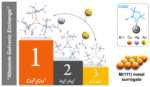
Data from: Absolute Templating of M(111) Cluster Surrogates by Galvanic Exchange
- Density Functional Theory Methods were used to calculate several carbene coinage metal clusters and their intermediates in a galvanic exchange process. Also, these methods calculated NICS scan, and WFN method for ELF.
- Date: 2019 to 2020
-
 Collection
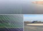
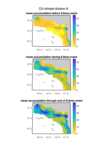
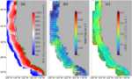
Data from: Airborne observations of shoaling and breaking internal waves
- This collection contains data presented in: "Airborne observations of shoaling and breaking internal waves." This includes a mosaic of sea surface temperature, spectral analysis of temperature structures, surface velocities, and areas undergoing breaking.
- Date: 2015-08-01
-
 Collection
Data from: Airborne observations of surface winds, waves and currents from meso to submesoscales
- Coincident and collocated high-resolution observations of surface currents and directional properties of surface waves collected from an airborne instrument, the Modular Aerial Sensing System (MASS), collected off the coast of Southern California.
- Date: 2021-05-18 through 2021-11-05
-
 Collection
Data from: Allostery through the Computational Microscope: cAMP Activation of a Canonical Signalling Domain
- This collection contains the molecular dynamics trajectories scripts and models used in the paper “Allostery through the computational microscope: cAMP activation of a canonical signalling domain”.
- Date: 2014-08-24
-
 Collection
Data from: Arctic ice-ocean interactions in an 8-to-2 kilometer resolution global model
- This data collection represents all UH8to2 model data used for the publication "Arctic ice-ocean interactions in an 8-to-2 kilometer resolution global model". This includes ocean and sea ice characteristics from the 2017-2020 UH8to2 model run.
- Date: Model representation: 2017 to 2020
-
 Collection
Data from: Autumn precipitation: the competition with Santa Ana winds in determining fire outcomes in southern California
- This dataset includes two versions of the Santa Ana Wind Regional Index (SAWRI) and Livneh precipitation data from 1948-2018.
- Date: Compiled: 1948 to 2018
-
 Collection
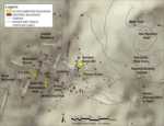
Data from: Building Cultural Heritage Resilience through Remote Sensing: An Integrated Approach using Multi-temporal Site Monitoring, Datafication, and Web-GL Visualization
- This collection integrates highly accurate 3D snapshots of Bodie's historic buildings before/after disturbance, or post-restoration, and other 3D geospatial data that were used to monitor and digitally preserve important cultural resources at Bodie California State Historic Park.
- Date: 2015 and 2020
-
 Collection
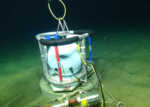
Data from: Calibrated absolute seafloor pressure measurements for geodesy in Cascadia
- Raw and corrected pressure data from campaign-style surveys of absolute calibrated sea pressure using an Absolute Self-Calibrating Pressure Recorder (ASCPR) in the Cascadia subduction zone from 2014 to 2017.
- Date: 2014 to 2017
-
 Collection
Data from: Carbon and Oxygen Isotopic Fractionation in the Products of Low-Temperature VUV Photodissociation of Carbon Monoxide
- Carbon and oxygen isotopic fractionation during photodissociation by VUV photons. This Matlab based model only calculates the isotope effect in the self-shielding process and not by any other means (e.g., predissociation). Data files are included.
- Date: 2016 to 2018
-
 Collection
Data from: Carbonic Anhydrases, EPF2 and a Novel Protease Mediate CO2 Control of Stomatal Development
- RNA-Seq experiments analyzing the Arabidopsis response to low and elevated carbon dioxide growing conditions were conducted to capture early signaling events as seedlings were adapting to stress.
- Date: 2012 to 2013
-
 Collection
Data from: Characterizing Non-phase-locked Tidal Currents in the California Current System using High-frequency Radar
- Processed time series from HFR, power spectra from HFR, and fitted harmonic constituents from analyzed HFR. Data from a bottom pressure sensor used in suppl. Scripts used in the study to analyze and process data and to make visualizations.
- Date: 2012-01-01 to 2021-04-01
-
 Collection
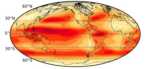
Data from: Climate change intensification of horizontal water vapor transport in CMIP5
- The dataset contains simulations of water vapor transport from 22 CMIP5 models including the historical, RCP4.5, and RCP8.5 runs.
- Date: 2014 to 2015
-
 Collection
Data from: Cobble Tracking Observations at Torrey Pines State Beach, CA, USA
- Wave data and cobble locations at Torrey Pines State Beach, San Diego, California.
- Date: 2021 to 2023
-
 Collection
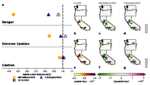
Data from: Commitment Problems or Bidding Wars? Rebel Fragmentation as Peace Building
- This project uses an original dataset of field commanders in post-civil war Tajikistan to show that warlords from the victorious faction were as likely to be purged from the ruling coalition in a given year as warlords from the defeated faction.
- Date: 2012
-
 Collection
Data from: Continuous Evaluation of Ligand Protein Predictions: A Weekly Community Challenge for Drug Docking
- All structures and RMSDs used in Continuous Evaluation of Ligand Protein Predictions: A Weekly Community Challenge for Drug Docking are provided here.
- Date: 2017 to 2018
-
 Collection
Data from: Contrasting Local and Long-Range-Transported Warm Ice-Nucleating Particles During an Atmospheric River in Coastal California, USA
- Data, modeling results and analyses supporting research into meteorology and ice nucleating particles.
- Date: 2016-03-05 to 2018-05-01
-
 Collection
Data from: Cusp and mega cusp observations on a mixed sediment beach
- The dataset contains elevation rasters and gravel/cobble locations (North American Datum of 1983 (NAD 83), North American Vertical Datum of 1988 (NAVD 88)).
- Date: 2018 to 2019
-
 Collection
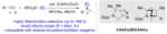
Data from: Cyclic(Alkyl)(Amino)Carbene Ligands Enable Cu-Catalyzed Markovnikov Protoboration and Protosilylation of Terminal Alkynes: A Versatile Portal to Functionalized Alkenes
- Included are the Gaussian output files (.chk, .fchk, and .log) from DFT calculations on the free carbenes explored in the protoboration and protosilylation of alkynes.
- Date: 2020 to 2021
-
 Collection
Data from: Diminished efficacy of regional marine cloud brightening in a warmer world
- Marine cloud brightening simulation output generated using the Community Earth System Model (CESM) version 2.2 described in Wan et al. (accepted).
- Date: 2022-04 to 2023-12