Browse by Collection: UCSD Research Data Collections
View current collections below. Click an image or link for a full description.
Page 1 of 5
Search Results
-
 Collection
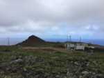
Measurements and Analysis Products from Baselining the Indirect Effect by Improving Quantification of Sea Spray and Marine Sources at Ascension Island during LASIC
- This collection provides data and codes used to retrieve aerosol mode fitting parameters, Hoppel minimum diameters from measured particle size distributions, cloud supersaturations, and cloud microphysical properties during the ARM LASIC campaign.
- Date: 2020 to 2024
-
 Collection
Data from: Observations and Numerical Simulations of the Onset and Growth of Langmuir Circulations
- This collection contains data from observations and numerical simulations of Langmuir circulations, along with the relevant routines to generate figures in Andriatis et al. 2024.
- Date: 2020-11-04 to 2020-11-25
-
 Collection
Data from: Characterizing Non-phase-locked Tidal Currents in the California Current System using High-frequency Radar
- Processed time series from HFR, power spectra from HFR, and fitted harmonic constituents from analyzed HFR. Data from a bottom pressure sensor used in suppl. Scripts used in the study to analyze and process data and to make visualizations.
- Date: 2012-01-01 to 2021-04-01
-
 Collection
Data from: NetSci: A Library for High Performance Biomolecular Simulation Network Analysis Computation
- This collection contains trajectory and molecular dynamics simulation output data for NetSci: A Library for High Performance Biomolecular Simulation Network Analysis Computation.
- Date: 2022-01-01 to 2024-04-01
-
 Collection
San Diego County GIS Data
- This collection contains GIS or geospatial data for San Diego County. Datasets were originaly acquired from the SanGIS and SANDAG Regional Data Warehouse and the San Diego Open Data Portal.
- Date: 1986 to present
-
 Collection
Genotype data from Crl:CFW(SW)-US_P08 stock of outbred mice
- Genotype data for CFW mice for the GWAS for age-related hearing loss.
- Date: 2021 to present
-
 Collection
Data from: Sensitivities of the West Greenland Current to Greenland Ice Sheet Meltwater in a Mesoscale Ocean/Sea Ice Model
- Diagnostics from a high-resolution global coupled ocean/sea-ice (POP/CICE5) simulations. Diagnostics are calculated based on 1992-1993 for three meltwater forcing experiments: a control run, surface forcing, and spread forcing.
- Date: Model creation: 2016 to 2023. Model representation: 1992 to 1993
-
 Collection
Educational Dataset Service Collection: Machine-learning suitable datasets curated for use in instruction
- Curated datasets appropriate for use in machine learning in instruction and research, including real research datasets, sanitized and synthetic administrative data from campus sources, and datasets commonly used for training in specific disciplines.
- Date: 2024 to present
-
 Collection
Data from: Diminished efficacy of regional marine cloud brightening in a warmer world
- Marine cloud brightening simulation output generated using the Community Earth System Model (CESM) version 2.2 described in Wan et al. (accepted).
- Date: 2022-04 to 2023-12
-
 Collection
Data from: Toward Enhanced Reusability: A Comparative Analysis of Metadata for Machine Learning Objects and Their Characteristics in Generalist and Specialist Repositories
- This dataset contains data reported in the paper, Labou et al. 2023, which aims to understand how researchers are currently documenting machine learning (ML) research outputs for sharing, and the extent to which repository metadata fields enable reuse of ML objects.
- Date: 2021 to 2023
-
 Collection
Aerosol Measurements at Utqiagvik, Alaska, from 2022 to 2027 for Sustaining The Utqiagvik Aerosol Record of Decades (STUARD)
- This collection contains submicron aerosol particle number size distributions, CCN spectra, submicron aerosol inorganic ions and organic components, and oxygen isotopes measured at Utqiagvik from June 2022-2027.
- Date: 2022 to 2026
-
 Collection
Data and Code from: Retaining Short-Term Variability Reduces Mean State Biases in Wind Stress Overriding Simulations
- Fortran source code developed to override wind stress with a climatology in the Community Earth System Model (CESM) v. 1.2 and resulting GCM output data from Luongo et al. (2024).
- Date: 2022 to 2023
-
-
 Collection
Data from: Impacts of Dropsonde Observations on Forecasts of Atmospheric Rivers and Associated Precipitation in the NCEP GFS and ECMWF IFS models
- ECMWF and NCEP IVT and precipitation data from control forecasts and data denial forecasts (without dropsondes assimilated) for Atmospheric River Reconnaissance (AR recon) 2019 and 2020.
- Date: 2019-02-01 to 2019-03-01 and 2020-01-24 to 2020-03-16
-
 Collection
BindingDB: Measured Binding Data for Protein-Ligand and Other Molecular Systems
- This collection contains the full BindingDB dataset of experimental protein-ligand and host-guest binding data.
- Date: 2000 to present
-
 Collection
Data from: Observations of Tidally Driven Turbulence over Steep, Small-scale Topography Embedded in the Tasman Slope
- In-situ observations from the Tasman Tidal Dissipation Experiment (TTIDE) collected around a small-scale bump embedded in the continental slope of Tasmania.
- Date: 2015-01 to 2015-03
-
 Collection
CCHDO Hydrographic Data Archive
- The CCHDO Hydrographic Data Collection contains high quality, global, vessel-based CTD and Niskin bottle data from GO-SHIP, WOCE, CLIVAR and other repeat hydrography programs past and present.
- Date: 1972 to present
-
 Collection
Standard Operating Procedure Documents for Coral Reef Ecological Monitoring
- This collection contains documents describing methods used by the Sandin Lab to collect standardized coral reef community ecology data.
- Date: 2010 to Present
-
 Collection
100 Island Challenge Collection
- The 100 Island Challenge is a collaborative effort to describe the variation of coral reefs from across the globe. We combine classical field surveys with innovative imaging and data technologies to archive reefs digitally and watch how populations change through time.
- Date: 2012 to present
-
 Collection
Center for Environmental Imaging Collection
- The Center for Environmental Imaging (CEI) is an effort to digitally archive imagery of the natural world. This collection includes image datasets from a diversity of projects and environmental habitats.
- Date: 2012 to present
-
 Collection
Data from: Readily Available Primary Aminoboranes as Powerful Reagents for Aldimine Synthesis
- Date: 2017 to 2018
-
 Collection
Data from: Ocean Surface Salinity Response to Atmospheric River Precipitation in the California Current System
- Oceanic and atmospheric measurements, reanalysis and modeled outputs in the California Current System.
- Date: 1992 to 2019
-
 Collection
Data from: Unexpected failure of regional marine cloud brightening in a warmer world
- Marine cloud brightening simulation output generated using the Community Earth System Model (CESM) version 2.2 described in Wan et al., (submitted).
- Date: 2022-04 to 2023-04
-
 Collection
Data from: QMrebind: Incorporating quantum mechanical force field reparameterization at the ligand binding site for improved drug-target kinetics through milestoning simulations
- The data set contains the files necessary to recalculate/reproduce the unbinding rates of ligands for the model host-guest systems and Hsp90-inhibitor complexes in the paper "QMrebind: Incorporating quantum mechanical force field reparameterization at the ligand binding site for improved drug-target kinetics through milestoning simulations."
- Date: 2021 to 2023
-
 Collection
Data from: Commitment Problems or Bidding Wars? Rebel Fragmentation as Peace Building
- This project uses an original dataset of field commanders in post-civil war Tajikistan to show that warlords from the victorious faction were as likely to be purged from the ruling coalition in a given year as warlords from the defeated faction.
- Date: 2012
-
 Collection
A dataset of chromosomal instability gene signature scores in normal and cancer cells from the human breast
- These data show the relative amount of chromosomal instability (CIN) in a diverse array of human breast cell types, including non-transformed mammary epithelial cells as well as cancer cell lines. Additional data is also provided from human embryonic and mesenchymal stem cells.
- Date: 2018 to 2023
-
 Collection
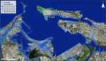
Data from: A climate vulnerability assessment of cultural heritage in the La Fortaleza and San Juan National Historic Site World Heritage Site
- Inundation threats related to climate change in San Juan Bay, Puerto Rico, which includes the World Heritage Site of La Fortaleza and San Juan National Historic Site. The map contains separate layers for sea level rise from NOAA's Sea Level Rise Viewer Tool, and layers for other relevant variables produced by the Coastal Resilience Evaluation and Siting Tool (CREST), acquired in Spring 2023.
- Date: 2023-04-03 to 2023-06-09
-
 Collection
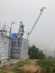
Aerosol Microphysics and Chemical Measurements at Mt. Soledad and Scripps Pier during the Eastern Pacific Cloud Aerosol Precipitation Experiment (EPCAPE) from February 2023 to February 2024
- Aerosol Microphysics and Chemical Measurements at Mt. Soledad and Scripps Pier during the Eastern Pacific Cloud Aerosol Precipitation Experiment (EPCAPE) from February 2023 to February 2024.
- Date: 2023-02-15 to 2024-02-14
-
 Collection
Data from: Overcrowded Housing Reduces COVID-19 Mitigation Measures and Lowers Emotional Health Among San Diego Refugees from September to November of 2020
- Data for the present cross-sectional study were collected between September 2020 and November 2020 as part of PANA’s biannual community survey to address the primary research question: What is the association between housing and COVID-19 vulnerability?
- Date: 2020-09 to 2020-11
-
 Collection
Data from: Observations of Surface Gravity Wave Spectra from Moving Platforms
- This collection consists of ocean and atmospheric observations (e.g., waves and winds) collected off the coast of San Diego and San Francisco California from instrumented Boeing Liquid Robotics SV3 Wave Gliders.
- Date: 2020-09-01 to 2021-11-04
-
 Collection
Data from: Cobble Tracking Observations at Torrey Pines State Beach, CA, USA
- Wave data and cobble locations at Torrey Pines State Beach, San Diego, California.
- Date: 2021 to 2023
-
 Collection
Data from: Machine learning for daily forecasts of Arctic sea-ice motion: an attribution assessment of model predictive skill
- MATLAB R2021b, Python and bash files used for data download and analysis. Processed data and MATLAB R2021b plotting files.
- Date: 1989 to 2021
-
 Collection
Data from: Arctic ice-ocean interactions in an 8-to-2 kilometer resolution global model
- This data collection represents all UH8to2 model data used for the publication "Arctic ice-ocean interactions in an 8-to-2 kilometer resolution global model". This includes ocean and sea ice characteristics from the 2017-2020 UH8to2 model run.
- Date: Model representation: 2017 to 2020
-
 Collection
Data from: A Climatic Sand Management Model for Cardiff State Beach, CA
- Annual mean beach width and nearshore sand volume survey estimates for 2000-2019 at South Torrey Pines and Cardiff State Beach, CA, and associated sediment budget modeling code for Cardiff State Beach.
- Date: 2000 to 2021
-
 Collection
Data from: Multi-Source Feature Fusion for Object Detection Association in Connected Vehicle Environments
- This dataset contains labeled virtual and real-world examples of object detection association in a connected vehicle environment.
- Date: 2020 to 2022
-
 Collection
Observations of Solar Analog Field Stars from the Hamilton Echelle Spectrograph at Lick Observatory
- This observing program used the Hamilton Echelle Spectrograph on the three meter Shane telescope at Lick Observatory to obtain high resolution spectroscopic observations of 211 solar analog field stars.
- Date: 2013 to 2014
-
 Collection
Data from: Identification of weakly- to strongly-turbulent three-wave processes in a micro-scale system
- Height of water surface at center of 40uL sessile drop at 115,200fps for ~1s during actuation by ~7MHz thickness mode ultrasound. Each data set was taken at the indicated ultrasound input power level (from 0-350 mW).
- Date: 2021-11-28 to 2022-01-18
-
 Collection
Data from: Calibrated absolute seafloor pressure measurements for geodesy in Cascadia
- Raw and corrected pressure data from campaign-style surveys of absolute calibrated sea pressure using an Absolute Self-Calibrating Pressure Recorder (ASCPR) in the Cascadia subduction zone from 2014 to 2017.
- Date: 2014 to 2017
-
 Collection
Data and Code from: 3D Reconstruction and Segmentation of Barely Visible Impact Damage in Composites from Pulse-Echo Ultrasonic C-Scans
- 26 processed pulse-echo ultrasonic C-scans of composites with barely visible impact damage with varying layups and impact energies, with calculated time-of-flight, contours of damaged regions, damage depth map, and 3D reconstruction of the damage state.
- Date: 2022 to 2023
-

-
 Collection
Data from: North American Monsoon Impacts Southern California’s Coastal Low Clouds
- This collection contains data from "North American Monsoon Impacts Southern California’s Coastal Low Clouds" (Clemesha et al. 2023). Data files include: satellite-derived Coastal Low Cloudiness (CLC) for May - September 1996 - 2020, seasonal cycle fit of CLC used to create daily anomalies, San Diego airport cloud cover, precipitable water content from 850 to 300 hPa from observations in southern and northern California, a previously published single column model radiative scheme with input and outputs files used in this study.
- Date: May through September, 1996 to 2020
-
 Collection
Research based PAM50 Signature from the Women's Healthy Eating and Living (WHEL) Study
- PAM50 subtype calls, ROR risk groups and scores are provided.
- Date: 2015-07-29 to 2015-11-06
-
 Collection
Data from: Effect of atmospheric forcing resolution on simulated mixed layer depth in the North Pacific
- This dataset contains daily output from two eddying ocean simulations in the North Pacific. The two experiments have the same configuration except for the atmospheric forcing resolution.
- Date: 2014 to 2018
-
 Collection
Genotype data from: NIDA Center for GWAS in Outbred rats
- This collection contains genotype data collected as part of the NIDA Center for GWAS in Outbred rats and more than 10 additional research projects that use N/NIH heterogeneous stock (HS) outbred rats.
- Date: 2014 to present
-
 Collection
Abraham A. Palmer Lab Research Data Collection
- We are studying the relationship between genotype and phenotype, especially behavioral phenotypes. Palmer Lab members collaborate on federally-funded projects that use a variety of species including humans, rats, mice, and zebrafish. A major focus of this work has been on developing and refining methods for genome-wide association studies (GWAS) in model organisms and integrating these results with expression QTLs (eQTL) and other -omics to identify specific and testable hypotheses about the relationship between genes and behavior.
- Date: 2006 to present
-
 Collection
The Center for GWAS in Outbred Rats Database (C-GORD)
- C-GORD (The Center for GWAS in Outbred Rats Database) provides access to the data generated by the NIDA center for genetic studies of drug abuse and other behaviors as well as physiological phenotypes in N/NIH heterogeneous stock (HS) rats; the data is collected by more than 15 research projects.
- Date: 2014 to present
-
 Collection
Data from: Mechanisms of heat flux across the Southern Greenland continental shelf in 1/10° and 1/12° ocean/sea ice simulations
- Volume and heat fluxes across the Greenland continental shelf in two eddy-active coupled ocean/sea-ice simulations.
- Date: 2005 to 2009
-
 Collection
Data and Code from: Measuring Turbulent Dissipation with Acoustic Doppler Velocimeters in the Presence of Large, Intermittent, Infragravity Frequency Bores
- Velocity data from Los Peñasquitos Lagoon and processing code to help researchers reproduce ADV de-spiking and turbulent spectrum calculation methods that work in the presence of non-linear, intermittent dynamics as well as a generally applicable, robust inertial sub-range fitting method.
- Date: 2020-02-02 to 2020-02-14
-
 Collection
Data from: Near-Inertial Surface Currents Around Islands
- This collection contains numerical model output from a linear 1.5-layer reduced gravity model. These simulations are presented in Siegelman et al. (2022), which examines the behavior of near-inertial surface currents around circular islands.
- Date: 2019 to 2021
-
 Collection
Southern Ocean Carbon and Climate Observations and Modeling (SOCCOM) and Global Ocean Biogeochemistry (GO-BGC) Biogeochemical-Argo Float Data Archive
- Data from biogeochemical Argo profiling floats within the SOCCOM and GO-BGC programs. Additional floats outside of these programs may also be included, provided their data-streams are managed by the Monterey Bay Aquarium Research Institute (MBARI).
- Date: 2014-03-27 to present