Browse by Collection: UCSD Research Data Collections
View current collections below. Click an image or link for a full description.
Page 7 of 21
Search Results
-
 Collection
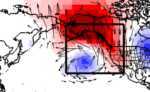
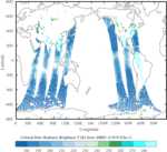
Historical Catalog of Winter Weather Regimes Impacting California, 1949-2017
- This dataset contains a historical catalog of daily atmospheric winter weather regimes observed over the North Pacific and western North America spanning 1949-2017. These weather regimes have been identified as important drivers of atmospheric river landfalls, Santa Ana winds, floods, and wildfires in California.
- Date: November-February 1949 to 2017
-
 Collection
Data from: SEEKR2: Versatile Multiscale Milestoning Utilizing the OpenMM Molecular Dynamics Engine
- This data set contains the files necessary to recreate the results in the paper "SEEKR2: Versatile Multiscale Milestoning Utilizing the OpenMM Molecular Dynamics Engine".
- Date: 2020-08 to 2022-03
-
 Collection
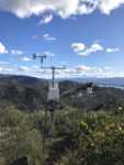
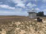
Center for Western Weather and Water Extremes (CW3E) Surface Meteorological Observational Dataset
- CW3E Surface Meteorological Observational Dataset: temperature, relative humidity, pressure, precipitation, and soil moisture and temperature at six levels collected every 2 minutes, from 11 stations in the Russian, Yuba, Feather, and Prado watersheds.
- Date: 2017 to present
-
 Collection
XRF and FTIR data from Pismo Beach Air Quality Study from May 2019 - May 2021
- XRF and FTIR atmospheric aerosol measurements from five campaigns conducted in the Oceano Dunes from May 2019 to May 2021. This includes dust, sea salt, non-sea salt sulfate, organic mass, and an unidentified fraction.
- Date: 2019-05-14 to 2021-05-24
-
 Collection
Scripps Argo Trajectory-Based Velocity Product
- This collection contains absolute velocity estimates from quality controlled Argo trajectory files. Both Scripps trajectory products include trajectories from Core, BGC and Deep Argo floats starting in 2001. The Scripps trajectory products provide velocities between 800-1200 dbar or 100-6200 dbar.
- Date: 2001 through 2020
-
 Collection
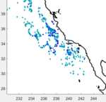
Data from: Using a Lagrangian particle tracking model to evaluate impacts of El Niño-related advection on euphausiids in the southern California Current System
- These supplemental animations depict particle backtracks for six euphausiid species sampled in the southern California Current System in spring, 2008-2017. The particle model runs four months backward to determine winter water mass origins.
- Date: 2007-11-01 to 2017-03-31
-
 Collection
Data from: Quantitative regional observations of the geological influence on primary sandy beaches
- The dataset includes mapped beach elevations, and gravel/bedrock locations in GeoTIFF format.
- Date: 2017-10-01 to 2021-03-31
-
 Collection
Data from: Impact of Atmospheric River Reconnaissance Dropsonde Data on the Assimilation of Satellite Data in GFS
- This collection are the satellite radiance data from the data denial experiments for the 2020 atmospheric river reconnaissance. The data are generated by the NCEP GDAS system during January 24 – March 18, 2020, corresponding to analyses in Zheng et al. 2022.
- Date: 2020-01-24 to 2020-03-18
-
 Collection
Data from: Retrieval of the Sea Spray Aerosol Mode from Submicron Particle Size Distributions and Supermicron Scattering during LASIC
- This collection contains sea spray mode fitting parameters retrieved from Mie inversion of submicron size distributions and supermicron scattering during the LASIC and NAAMES campaigns. Sea spray mode retrieval and Mie scattering codes are also provided.
- Date: 2020 to 2022
-
 Collection
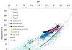
Data from: Metabolic rates in the Agua Hedionda Lagoon during the 2020 Southern California red tide event
- A time series from autonomous SeapHOx sensors (pH, dissolved oxygen (DO), salinity, temperature, and pressure) in the Agua Hedionda Lagoon, captured baseline conditions in 2018 and the effects of a massive red tide occurring along the Southern & Baja California coast during the spring of 2020.
- Date: 2018-11-02 to 2018-12-24 and 2020-02-05 to 2020-06-14