North Pacific Ocean : plans in the Marianas

- Collection
- Description
-
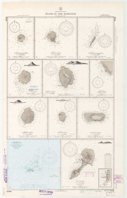
(Urakasu To) Farallon de Pajaros (Uracas I.); (Sarigwan To) Sarigan Island; (Medeiniija To) Farallon de Medinilla; (Assonguson To) Asuncion (Assongsong) Island; (Agurigan To) Aghrihan Island; (Agurigan To) Agrihan Island, Agrihan Anchorage (Agurigan Byochi); (Aramagan To) Alamagan Island; (Guugwan To) Guguan Island; Anatahan Island; Pagan Island; North Pacific Ocean, Minami-Tori Shima (Marcus Island)
- Creation Date
- 1927-04-01
- Date Issued
- 1968-03-04
- Publisher
- Note
-
From Japanese surveys to 1924
Inset: Apaan Bay
Relief shown by contours and spot heights; depths shown by soundings and isolines
- Geographic
- Topics
- Cartographics
Polygon: 24.31944444,144.875 24.31944444,154.0125 15.975,154.0125 15.975,144.875 24.31944444,144.875
Formats
View formats within this collection
- Language
- No linguistic content; Not applicable
- Series
-
2nd edition, No. 5358
- Copyright
-
Public Domain (US)
Use: This work is available from the UC San Diego Library. This digital copy of the work is intended to support research, teaching, and private study.
Constraint(s) on Use: This work may be used without prior permission.
- Digital Object Made Available By
-
UC San Diego Library, UC San Diego, La Jolla, CA 92093-0175 (https://library.ucsd.edu/dc/contact)
- Last Modified
2022-11-02