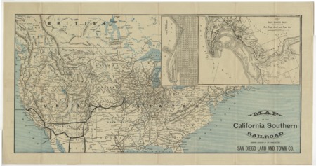
Map of the California Southern Railroad, showing location of the lands of the San Diego Land and Town Co
- Collection
- Creation Date
- circa 1883
- Creator
- Physical Description
-
1 map ; 33 x 68 cm
- Material Details
-
cartographic image
- Note
-
Includes northern Mexico as far south as Chihuahua and some of what is now Canada including all of Winnipeg Lake. Northeastern U.S. shown only in insets; southern Texas and southern Florida not shown
Insets: Map of San Diego bay and the lands of the San Diego Land and Town Co. -- National City, Calif
Northeastern U.S. shown only in insets; Texas south of Galveston and Florida south of Cedar Keys not shown
Shows railroads of U.S., particularly those of the west and northern Mexico
- Geographics
- Genre
- Corporate Names
- Topics
Format
View formats within this collection
- Language
- English
- Identifier
-
Mms: 991000011919706535
- Publication
-
Boston, Rand, Avery & Co.
- Copyright
-
Public domain (US)
Use: This work is available from the UC San Diego Library. This digital copy of the work is intended to support research, teaching, and private study.
Constraint(s) on Use: This work may be used without prior permission.
- Digital Object Made Available By
-
Special Collections & Archives, UC San Diego, La Jolla, 92093-0175 (https://lib.ucsd.edu/sca)
- Last Modified
2024-07-20