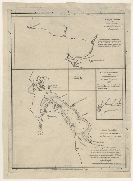
Plan of Port Sn. Diego on the west coast of California : lat. 323̊9ʹ n. long. 124̊ʹ w. fr. Sn. Blas

- Collection
- Creation Date
- 1789
- Creators
- Publisher
- Physical Description
-
1 map ; 33 x 24 cm
- Material Details
-
cartographic image
- Note
-
Includes inset of "Plan of the Road del Principe in the Channel of Sn. Barbara by Don Josef Tobar y Tamariz, 1786" and map of "Plan of Monterey on California by Don Josef Tobar y Tamariz, 7th December 1786."
Map dated 1782
Reference meridian: San Blas, Mexico
Soundings in fathoms
"N.B. These plans were taken from Spanish MSS. Communicated by John Henry Cox Esqr. to whom this plate is inscribed by his most obliged Dalrymple."
- Geographics
- Genres
- Topic
Format
View formats within this collection
- Language
- English
- Identifier
-
Mms: 991000000919706535
- Statement Of Responsibility
-
[Juan Pantoja y Arriaga]
- Publication
-
[London], A. Dalrymple
- Series
-
Hill Collection of Pacific Voyages
- Copyright
-
Public domain (US)
Use: This work is available from the UC San Diego Library. This digital copy of the work is intended to support research, teaching, and private study.
Constraint(s) on Use: This work may be used without prior permission.
- Digital Object Made Available By
-
Special Collections & Archives, UC San Diego, La Jolla, 92093-0175 (https://lib.ucsd.edu/sca)
- Last Modified
2024-07-20