Cool Santa Fe summer way to California
- Collection
- Creation Date
- 1914
- Creator
- Physical Description
-
1 folded sheet ([10] panels) : illustrations, map ; 31 x 40 cm, folded to 16 x 8 cm
- Material Details
-
text
- Note
-
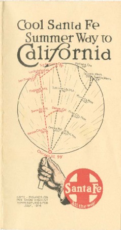
"Diagram of comparative summer temperatures, July, 1914"-- Bottom of map
"Reasons why the Santa Fe is the most comfortable summer route to California"--Across 5 outside panels
"The Santa Fe is the cool way to California in summer. Official diagram below tells the story of 'Altitude' vs. 'Latitude.' The higher up you go, during the warm months, the cooler it is; that's the reason why."--Head of map
"Worth remembering when you take that 1915 Panama Exposition trip"--Across 4 outside panels
- Geographics
- Genre
- Corporate Name
- Topics
Format
View formats within this collection
- Identifier
-
Mms: 991000056879706535
- Publication
-
Chicago, W.J. Black, Passenger Traffic Manager
- Copyright
-
Public domain (US)
Use: This work is available from the UC San Diego Library. This digital copy of the work is intended to support research, teaching, and private study.
Constraint(s) on Use: This work may be used without prior permission.
- Digital Object Made Available By
-
Special Collections & Archives, UC San Diego, La Jolla, 92093-0175 (https://lib.ucsd.edu/sca)
- Last Modified
2024-07-19