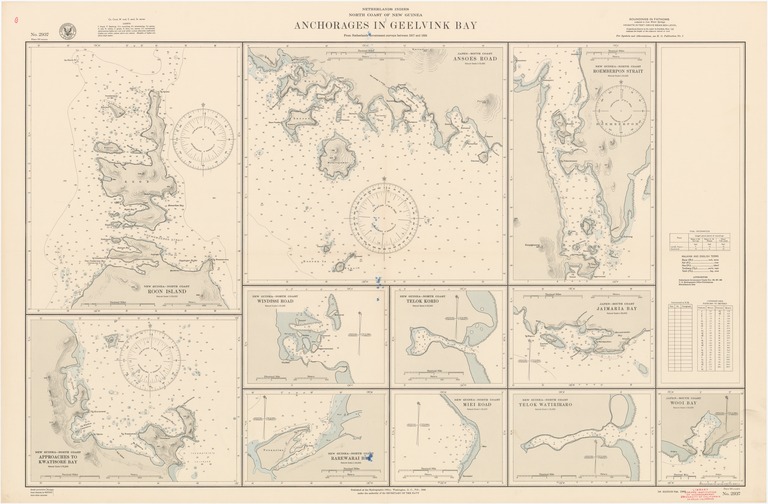
Netherlands Indies : north coast of New Guinea : anchorages in Geelvink Bay

- Collection
- Description
-
New Guinea-north coast, Roon Island; New Guinea-north coast, approaches to Kwatisore Bay; Japen-south coast, Ansoes Road; New Guinea-north coast, Roemberpon Strait; New Guinea-north coast, Windissi Road; New Guinea-north coast, Rarewarai Bay; New Guinea-north coast, Telok Korio; New Guinea-north coast, Miei Road; New Guinea-north coast, Telok Watiriraro; Japen-south coast, Jaimaria Bay; Japen-south coast, Wooi Bay
- Creation Date
- 1944-02-01
- Date Issued
- 1944-02-01
- Publisher
- Note
-
From Netherlands government surveys between 1917 and 1924
Relief shown by contours and spot heights; depths shown by soundings and isolines
- Geographics
- Topics
- Cartographics
Polygon: -1.65,134.1083333 -1.65,135.95 -3.283333333,135.95 -3.283333333,134.1083333 -1.65,134.1083333
Formats
View formats within this collection
- Language
- No linguistic content; Not applicable
- Series
-
1st edition, No. 2937
- Copyright
-
Public Domain (US)
Use: This work is available from the UC San Diego Library. This digital copy of the work is intended to support research, teaching, and private study.
Constraint(s) on Use: This work may be used without prior permission.
- Digital Object Made Available By
-
UC San Diego Library, UC San Diego, La Jolla, CA 92093-0175 (https://library.ucsd.edu/dc/contact)
- Last Modified
2022-11-02