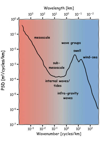
Data from: A Broadband View of the Sea Surface Height Wavenumber Spectrum
About this collection
- Extent
-
1 digital object.
- Cite This Work
-
Villas Bôas, Ana B.; Lenain, Luc; Statom, Nicholas (2022). Data from: A Broadband View of the Sea Surface Height Wavenumber Spectrum. UC San Diego Library Digital Collections. https://doi.org/10.6075/J0W0963R
- Description
-
Airborne lidar altimetry can measure the sea surface height (SSH) over scales ranging from hundreds of kilometers to a few meters. This collection has SSH observations taken during an airborne lidar campaign conducted in the spring of 2019 off the California coast in support of the Surface Water and Ocean Topography (SWOT) mission. The collection consists of NetCDF files with all data necessary to reproduce the figures in Villas Bôas et al. (2022), which were based on flights from March 28, 2019, and April 9, 2019. The data can be used in conjunction with code available in the following GitHub repository: https://github.com/biavillasboas/BroadbandSpectrum
- Date Collected
- 2019-03-28 to 2019-04-10
- Date Issued
- 2022
- Creator
- Principal Investigator
- Engineer
- Note
-
Product license information: Ssalto/Duacs altimeter products produced and distributed by the Copernicus Marine and Environment Monitoring Service (CMEMS). For instructions on how to cite Ssalto/Duacs data, go to https://www.aviso.altimetry.fr/es/data/product-information/citation-and-aviso-products-licence.html
Acknowledgements: Thank you to the CNES & CLS teams for providing the geophysical corrections along the MASS flight tracks. - Funding
-
The production of this collection was supported by NASA award 80NSSC20K1136 through the SWOT program; NASA award 80NSSC19K1004 through the S-MODE program, and through NASA JPL contract 1618801.
- Topics
Formats
View formats within this collection
- Language
- English
- Identifier
-
Identifier: Ana B. Villas Bôas: https://orcid.org/0000-0001-6767-6556
Identifier: Luc Lenain: https://orcid.org/0000-0001-9808-1563
- Related Resources
- Villas Bôas, Ana B.; Lenain, Luc; Statom, Nicholas (2022). A Broadband View of the Sea Surface Height Wavenumber Spectrum. Geophysical Research Letters. https://doi.org/10.1029/2021GL096699
- Data courtesy of the Coastal Data Information Program (CDIP), Integrative Oceanography Division, operated by the Scripps Institution of Oceanography, under the sponsorship of the U.S. Army Corps of Engineers and the California Department of Parks and Recreation.” https://doi.org/10.18437/C7WC72
- The results contain modified Copernicus Climate Change Service information 2020. Neither the European Commission nor ECMWF is responsible for any use that may be made of the Copernicus information or data it contains. https://doi.org/10.24381/cds.adbb2d47
- The results contain sea level anomaly data modified from the Ssalto/Duacs altimeter products which are produced and distributed by the Copernicus Marine and Environment Monitoring Service (CMEMS), available at https://marine.copernicus.eu
- Jupyter Notebooks available at https://github.com/biavillasboas/BroadbandSpectrum
- Spectral analysis from AltiKa measurements that appear in Chereskin, Teresa K., et al. "Characterizing the transition from balanced to unbalanced motions in the southern California Current." Journal of Geophysical Research: Oceans 124.3 (2019): 2088-2109. https://doi.org/10.1029/2018JC014583
Primary associated publication
Source data
Software
Reference
 Library Digital Collections
