Data from: Cobble Tracking Observations at Torrey Pines State Beach, CA, USA
About this collection
- Extent
-
1 digital object.
- Cite This Work
-
Young, Adam P.; Matsumoto, Hironori; Spydell, Matthew S.; Dickson, Mark E. (2023). Data from: Cobble Tracking Observations at Torrey Pines State Beach, CA, USA. UC San Diego Library Digital Collections. https://doi.org/10.6075/J0CZ37B1
- Description
-
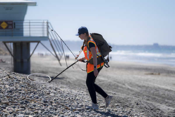
Data files contain detected RFID tagged cobble locations and associated wave conditions at Torrey Pines State Beach, CA. The coordinate systems for the data are UTM Zone 11, nad83, navd88, meters. RFID surveys were conducted with a handheld and custom mobile (ATV) system.
Abstract:
Cobbles provide a nature-based method to help generate beach stability. However, few detailed cobble movement observations exist. This study deployed 344 radio-frequency identification (RFID) tagged cobbles at a California beach in Nov-Dec 2020. Coincident LiDAR surveys quantified beach morphology. Cobbles were mapped daily for 10 days and then ~monthly until Jan 2023. Cobble detection rates ranged 17-92%, and generally declined with time (with slight increases during winter months). Cobble movement exhibited complex patterns, sometimes moving in opposing directions during the same time period. Large winter waves (up to ~4m) resulted in average displacements of 40m per month between Nov 2020 and Apr 2021. From Apr 2021 to Aug 2022, most cobbles were located high on the beach and net alongshore movements were relatively low, despite several moderate size (~2m) wave events. The largest wave event in Jan 2023 (>4m) moved cobbles to the highest elevations of the study period. The initial release location and accommodation space in the back beach influenced cobble movement and final position. Cobbles high on the beach were relatively stable compared to lower elevation cobbles, and more than half of all cobble detections were within 50m of the initial release location. However, three cobbles moved >500m. The probability distribution of displacement was approximately exponential. Statistically, alongshore cobble spreading followed a non-Gaussian sub-diffusive process. Despite myriad sources of noise, results suggest cobble shape and mass were related to maximum cobble displacement. Overall, displacements increased with incident wave energy and depended on elevation relative to total water level. - Date Collected
- 2021 to 2023
- Date Issued
- 2023
- Principal Investigator
- Contributors
- Geographics
- Topics
Formats
View formats within this collection
- Language
- English
- Identifier
-
Identifier: Adam P. Young: https://orcid.org/0000-0001-7985-9528
Identifier: Hironori Matsumoto: https://orcid.org/0000-0002-4637-7781
Identifier: Matthew Spydell: https://orcid.org/0000-0002-7861-792X
- Related Resources
- Young, A.P.; Matsumoto, H.; Spydell, M.; Dickson, M.E. (2023). Cobble Tracking Observations at Torrey Pines State Beach, CA, USA. Journal of Geophysical Research - Earth Surface.
- Image source: Erik Jepsen, UC San Diego. This image shows the handheld RFID cobble detection system at Torrey Pines State Beach. Copyright ©️ the Board of Regents of the University of California.
Primary associated publication
Collection image
 Library Digital Collections
