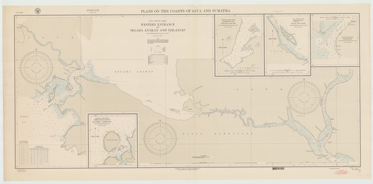
Plans on the coasts of Java and Sumatra

- Collection
- Description
-
Java-south coast, western entrance to Segara Anakan and Tjilatjap; Sumatra-west coast, Taroesan Bay, Telok Dalam; Java-north coast, Bantam (Banten) Bay, Kali Islands; Java-south coast, Tjilatjap
- Creation Date
- 1943-01-01
- Date Issued
- 1943-01-01
- Publisher
- Note
-
From various Netherlands government surveys
Inset: Sumatra-west coast, North Pagai Island, SI Laboe, Laboe Bay
Relief shown by hachures; depths shown by soundings and isolines
- Geographics
- Topics
- Cartographics
Polygon: -1.19,99.96 -1.19,109.17 -7.75,109.17 -7.75,99.96 -1.19,99.96
Formats
View formats within this collection
- Language
- No linguistic content; Not applicable
- Series
-
1st edition, No. 5863
- Copyright
-
Public Domain (US)
Use: This work is available from the UC San Diego Library. This digital copy of the work is intended to support research, teaching, and private study.
Constraint(s) on Use: This work may be used without prior permission.
- Digital Object Made Available By
-
UC San Diego Library, UC San Diego, La Jolla, CA 92093-0175 (https://library.ucsd.edu/dc/contact)
- Last Modified
2022-11-02